guerilla base camps in the phlippines during world war 2
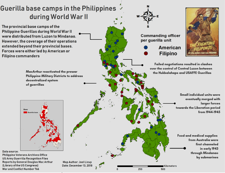
The inset map and main map depicts the different guerrilla movements and units across the Philippines to show how dispersed they were during the Japanese occupation. It also explains that different units were not solely controlled by Filipino commanders. The main map differentiates between which units were controlled by American or Filipino commanders. These movements were vital sources of intelligence for the Liberation forces of the Americans and were important symbols of resistance against the invaders. The inset map illustrates the specific provinces which were made into basecamps for the guerrilla units and it is important to note that their operations were not limited to the provincial boundaries.
Data:
The data was acquired through various digitized archives in the Philippine Veterans Office and the US Army. The archives are composed of compiled reports and lists of officers per unit. The distribution of the guerilla units range from Luzon to Mindanao. Certain provinces had multiple units that eventually were merged into a larger force such as in the cases of the Leyte Area command under Col. Kangleon, Col. Fertig in Mindanao and Volckmann in Northern Luzon. Each unit had either an American or Filipino commander that coordinated with the American forces based in Australia. The map depicts which units were controlled by Filipino or American commanders. Most Filipino commanders were situated in the Visayas region and most American commanders controlled the Luzon and Mindanao battalions. Filipinos, however, composed most of the population of the guerrilla forces despite being controlled by American commanders.
Challenge:
The most challenging part of creating the map is getting the data of each unit due to the lack of sufficient documents. The main source of data for this map are the old documents and reports during World War II. While there are available documents online, there are reports which explain that not all documents were preserved due to the danger of keeping such documents during the war. Also, some documents pertaining to the guerrillas are limited to those who were recognized by the US Armed Forces a few years after the war. The major issue is that the data may be biased towards the American-led forces as the main force for unification of the guerilla units. It was also difficult to choose which feature to use given the voids in some data. The future step would be to collate and preserve further the local narratives of the guerilla forces.
Advice to beginner mappers
Maps help us visualize various discussions and simplify them. The first step will always be knowing what type of thematic map would best suit your topic and data. The aesthetics of the map would flow from there. Normally, maps that are relatable or well-understood by laypeople are maps that are straightforward and do not use too much details in presenting the main topic. There are some maps which are used by professionals that encapsulate or include a lot of details. However, if you want to target a large audience, the details must be concise and direct. Another tip for mapmaking would be to utilize simple colors/details that will guide the eyes of your audience to your main purpose in the map. Sometimes, mapmakers can use arrows or lines to guide the audience to a specific point or information in the map. If you’re lost, you always go back to the purpose of your map and what your objectives are.
