peregrinos hasta eternidad: Pilgrim deaths along camino de santiago (2007-2017)
El Camino de Santiago (the Way of Saint James) is a pilgrimage where pilgrims or peregrinos, through walking, by bicycle, or by horse-riding, give homage and veneration to the tomb of Santiago El Mayor, one of the apostles of Jesus Christ in Santiago de Compostela in Galicia, Spain. Thousands and thousands of people from various walks of life, from different continents, participate. However, in the contemporary period, the Camino is not just for religious purposes anymore, some are doing this for leisure, recreation, tourism, and for personal reasons.
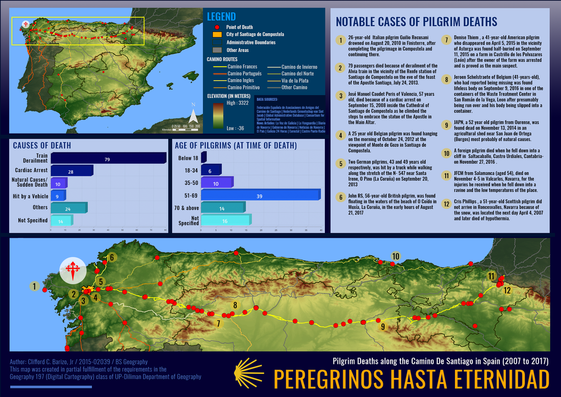
There are various routes where peregrinos may start such as the Camino Primitivo (Primitive Way), the mostly walked Camino Frances (French Way) that starts in France, the Camino del Norte, Camino Portugues, among others. I completed the Camino last June wherein I started in the City of Lugo in the route of the Camino Primitivo. It is a very unforgettable experience that brought me to new heights (literally and figuratively), even though I reached Santiago. However, some are unfortunate because they are not able to complete the camino because of death.
The Camino de Santiago is a very long journey that ranges over hundreds of kilometers and requires a lot of effort and stamina especially if the weather is hot. Pilgrims should have a watchful eye and be careful with cars and ravines in dangerous places. A number of deaths were caused by crimes, but for other unfortunate circumstances, were also caused by fatal accidents Because of this, I was motivated to create a map that was inspired by my experience. I, myself, walked also the Camino and thankfully, reached Santiago alive and inspired. The objective of this map is to illustrate the various causes of death and what may be the factors of these deaths (i.e. topography). This may also illustrate where pilgrims should be more aware for their safety and well-being. The scope of the map will be all the major routes of the Camino within Spain.
I requested data from various Spanish associations, offices, and organizations relating to the Camino, and even the Cathedral and the Archbishopric of Santiago de Compostela regarding the deaths along the Camino, but, lamentably, the requests yielded negative results. So, I resorted to base only online from the Federación Española de Asociaciones de Amigos del Camino de Santiago for their list of pilgrims (and some notable people related to the Camino) who died in the course of the year. They have an annual publication that contains this list. However, this was in Spanish, so I have to translate everything through the process of formal translation and dynamic equivalence, twice. I have to check the dictionary for some unfamiliar words because my knowledge of the Spanish language is only limited. To confirm some deaths without causes, I decided to rechecked it with some news articles from different Spanish news outlets online. Afterwhich, I plotted the deaths in the pueblos and ciudades through the use of Google Earth. The death of pilgrims that will be depicted includes, but not limited to, health-related and sudden causes (i.e. heart attack), accidents (vehicular collisions, drowning, falls,), and assaults.
Of course, the Camino is not the Camino without its various routes, so, I searched for a kmz file of the routes,and there is only one site which includes not only Spain but also in the neighbouring Portugal and France. Other data are already online, so it is easier for me.
I am very happy creating the map. However, the most challenging parts of creating this map is the layouting as well as the plotting of deaths. Even though I am inclined to do publication materials, I had a hard time in dealing with the arrangement of elements in the map itself, as well as in deciding what color scheme should I use, especially on the various routes of the Camino. But, I decided the color scheme, mainly on hues of blue and yellow- the colors of the markers along the Camino, which, I think, will give justice and more aesthetic design to the map. In the end of the day, I loved the way how this map was executed, thanks to my mentor Ms. Fara Manuel for her invaluable help and her amazing and relevant insights and comments.
After all the activities and creating the final map project, I have an advice to beginner mappers: do your maps with noble simplicity. Simplicity is beauty. Do it with intrinsic balance, do it with love. Don’t just create maps, create maps that we will learn from, that will tell a story, that will tell how the author created it. Maps are media of encounter, it gives an impression and knowledge to the reader. Create a map that is based and will achieve your objectives because in the end of the day, I think it is better to express in Filipino: aanhin mo ang mapang maganda kung di naman naipapakita ang layunin nito.
